My Wednesday morning harp lesson takes me to Perryopolis. I've been taking lessons for about a month, and putting Ghidra, the Terror-trike, in the back of the mini-van. My hour-long lesson which was to have ended around 1 o'clock didn't end until 3pm. We talked about electronics, amps, pre-amps, digital sound recording -- and I didn't have a harp lesson, but I did learn a bit. Yesterday's trip sent me to West Newton for a minor derailleur adjustment. It was late afternoon when I got there.
West Newton Bicycle Shop is conveniently located adjacent to the trail. The young man (high-school age) quickly made the adjustment, so quickly that I didn't have time to look the entire shop over. Five dollars plus tax... a bargain. A quick trip across Rte. 136 took me to the West Newton Visitor Center at the reconstructed West Newton station. Closed. I missed meeting Betsy (a member of the Yahoo Group's GAP list) again. I later found out that Betsy works mornings. Stomach growling, I walked over to The Picnic Place across the street and ordered a roast beef sandwich and a bottle of water. It was tasty, if not a bit messy. I wore the sandwich well. I turned around and headed toward Cedar Creek Park.
I passed up the opportunity to explore the West Newton Cemetery. No bikes are allowed in, and I didn't feel like leaving Ghidrah out of my sight. I soon came to the site of the (not so) old Banning No. 4 mine.

You don't see a whole lot from the trail... a concrete loading silo, some other concrete buildings and a massive gob pile. Coal seams have many layers of slate runnning through them, each layer an inch or two. A gob pile is the shale (and some coal) that remains after the coal is cleaned from it. Author Bill Metzger says that a gob pile roughly represents 10% of the coal taken from a mine. This mine must have been awesome -- just look at the satellite view! A water treatment plant is on the river side of the trail. It's an active limestone doser that treats about 6 million gallons of acid mine drainage per day.

(photo left: map of general area, photo right: loading silo, photo lower right: Gob pile, photo lower left: LTV Steel doser, below: Satellite photo courtesy Google Maps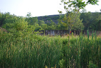


That's not a mountain in the background - it's a huge pile of slate -- what was left behind after the coal was extracted.
View Banning No. 4 in a larger map
_____________________________________________________________________________
Pseudofossils
 As I approached Cedar Creek Park, I stopped to take pictures of the Liesegang Structures (Liesegang Rings) near milepost 36. These formations in weathered sandstone are comprised of iron mineral concentrations within the stone which were resistant to erosion. They left a bizarre honeycomb effect:
Pretty cool, yes?

A birdwatcher was sitting on a bench just outside of Cedar Creek Park, binoculars in hand. I asked him if he saw anything interesting today, he said, "Not a darned thing". I forgot to specify whether feathered or human -- no matter, the trail was barely peopled.
The bike concession was open, but quiet. I stopped to look at a Sun recumbent and resisted the urge to ask for a test ride. The guys were interested in Ghidrah and I let them take him for a ride. After we exchanged more pleasantries, I excused myself to go look for the Port Royal tufa. I rode a short distance past the organized and bike camping areas and past the upstream boundary of the park to mile 38.
 "Tufa belong to a group of crust-like carbonate deposits that are formed through the organically and inorganically controlled precipitation of calcium carbonates from fresh water . The porosity in tufas is derived from authochtonous plants such as mosses, green algae or reed, which are encrusted by carbonates. Tufas are typically found as deposits of cool spring waters, which are supersaturated by calcium bicarbonate. The precipitation of carbonates in these meteogene deposits is assisted by photosynthesis of phototrophic microbes and plants. Generally, however, any decrease in the partial pressure of CO2 will trigger carbonate precipitation."
 --"Tufa." World of Earth Science. 2003. Retrieved June 03, 2010 from Encyclopedia.com: http://www.encyclopedia.com/doc/1G2-3437800624.html
I stopped at the memorial for the Port Royal Mine Disaster of June 10-11, 1901. I thought I had a photo of the memorial, but must have lost it along with pictures from my 2007 trip when my hard drive crashed.Overshadowed by the 239 deaths at the nearby Darr Mine, loss of life at this disaster was officially listed at 20. A local historian claims an additional 10 lives were lost based on a review of cemetary records and other documents.
 I continued to the I70 overpass and turned around for the return trip. "X" marks the spot for Cedar Creek Park, the Port Royal Mine was located off of Port Royal Road.
The return trip was very pleasant. I was invited to join a group of riders for a trail ride and pot luck supper afterwards. I declined, but did say that I may take them up on their offer when they ride again in 2 weeks. The joggers were out -- the temperature was falling ever so slightly, but the sun was no longer beaming down from overhead. I saw a group (colony?) of whistlepigs (groundhogs) and chased a large doe down the trail.
As I got closer to West Newton, I noticed more people -- some boys on bikes, a couple with a Yorkie in a basket (sounds like a fast food dinner), a family with relatives visiting from Memphis. I stopped at a house near the Buddtown marker and chatted with Lester, who was sitting in his garage. We talked about people riding on the Passage, thru-riders, and lamented the fact that no one seems to take time to smell the roses. Lester owns the big purple house in Buddtown (first group of houses outside of West Newton near Mile 34). If he's out and about, take time out of your busy schedule to chat.


No comments:
Post a Comment